
Bibbulmun Track (Kalamunda–Albany)
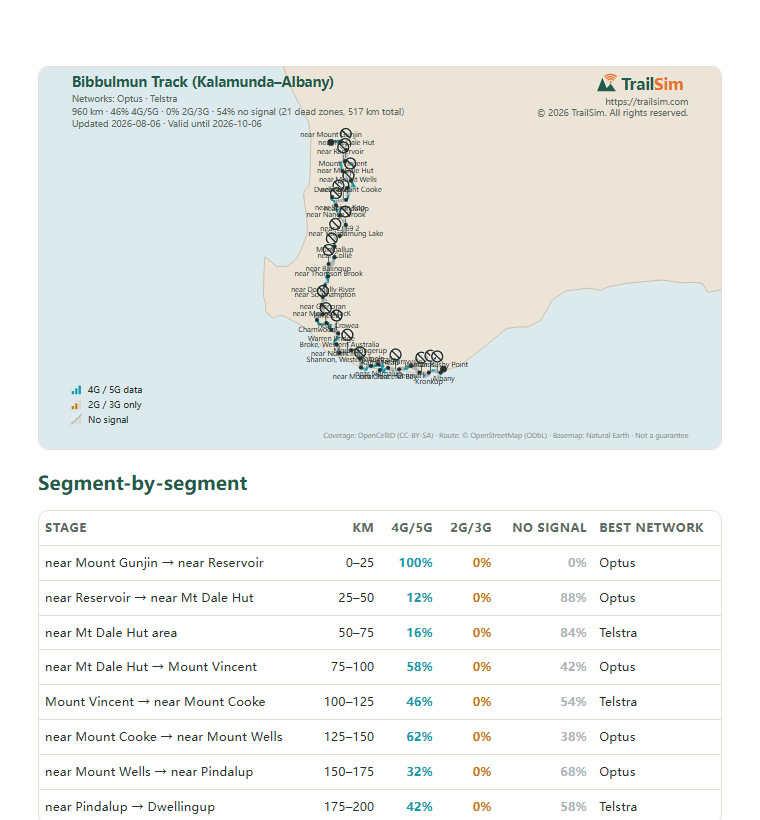
960 km analysed against the carriers' own transmitter licences·46% with signal, all of it 4G/5G·21 dead zones mapped·report included
Included with every order
- Secure checkout by Stripe
- eSIM QR code and coverage report by email within minutes
- 21 dead zones on this route — mapped in your report
- Plan days start on first use, not at purchase
- 14-day self-service refund before installation
Show 11 more 30-day plans
Coverage map

What you carry with you
The map above shows where the signal holds and where it goes. The report is the version you take with you: on the trail there is no signal, so it is a PDF you keep on your phone or print, plus a GPX track that puts every dead zone on your map app as you walk.
- Every stage of the route with its coverage, kilometre by kilometre
- The strongest network for each stage
- Every dead zone with its coordinates and GPS waypoints
- Printable PDF and a GPX track for your GPS or phone map
Included with every plan, emailed within minutes of purchase. Click a page to see it full size.
How this is estimated. Based on ACMA licence filings — where carriers are licensed to transmit, not where signal was measured. Full methodology in the report. Coverage data: Based on Australian Communications and Media Authority information, snapshot 2026-08-06. Route and place names: © OpenStreetMap contributors (ODbL). © 2026 TrailSim.
Frequently asked questions
How much data do I need for Bibbulmun Track (Kalamunda–Albany)?
Aim for at least 500 MB a day — comfortable headroom for daily navigation, booking accommodation, messaging home and uploading photos. The featured plan is picked on exactly that rule; size up if you stream, video-call or share your connection.
When do the plan days start counting?
On first use — installing the eSIM and connecting starts the clock, not the purchase date. You can safely buy weeks before your trip.
Does my phone support eSIM?
Most phones released since 2019 support eSIM, including iPhone XS and later, Google Pixel 3 and later, and most recent Samsung Galaxy models. Your phone must also be carrier-unlocked.
Why not a regular travel eSIM from Airalo or Holafly?
Any eSIM connects to the same physical networks. What TrailSim adds is the route check: we compare the carriers' own transmitter licences along your exact trail, pick the network combination that holds best there, and include the coverage report with every dead zone mapped — so you know before you go where the phone will and won't work.
What if parts of the route have no signal at all?
On most wild routes some stretches have no signal from any network — no eSIM can change that. The report marks every dead zone with GPS coordinates and length, so you can download offline maps for those sections and tell people at home when you'll be unreachable. Knowing where it drops is the point.
What if I change my mind after buying?
Uninstalled eSIMs qualify for a full self-service refund within 14 days of purchase — no questions asked. Once the eSIM is installed on a device it can no longer be returned. See the refund policy.