
Route 66 — Southern Plains (Oklahoma City–Albuquerque)
- 881 km analysed against real cell-tower data
- 92% fast 4G/5G data
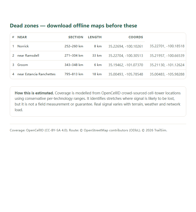
- 4 dead zones mapped (64 km)
Phone signal on the Southern Plains section of Route 66: where it drops
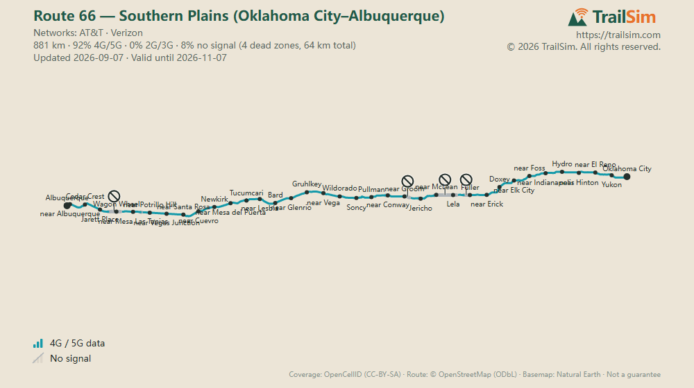
TrailSim estimate for the Southern Plains section of Route 66: 92% of its 881 km has fast 4G/5G data, and 4 dead zones total 64 km (real cell-tower data, snapshot 2026-09-07).
The stretches below describe the featured plan's networks (US:AT&T · US:Verizon); the figures above follow the plan you selected.
The signal is strongest between Oklahoma City and Yukon, where the model puts fast 4G/5G data at 100% of the stage. It runs thinnest between Lela and near McLean (0% fast data) — expect long stretches where maps and messages crawl or fail.
Choose your eSIM
Typical trip: ~4 days · ~2 GB at 500 MB a day. Plan days start on first connection, so this 30-day plan covers the whole trip.
Plan details
- Data
- 3 GB
- Validity
- 30 days, starting when the eSIM first connects — not at purchase
- Networks
- United States: Verizon (5G) · AT&T (5G)
- Speed
- 5G · no speed limit
- Calls & SMS
- Data only — no phone number. WhatsApp, FaceTime and other app calls work over data
- Hotspot
- Allowed — share data with your other devices
- Installation
- QR code by email within minutes; settings configure automatically on most phones (APN included in the email). Requires an eSIM-capable, carrier-unlocked phone
- Device
- Locks to the first phone it is installed on and cannot be moved
- Refunds
- Full self-service refund within 14 days while uninstalled — see the refund policy
- Top-up
- One-off plan — if you run out, buying another takes minutes
Data only · Hotspot allowed · Days start on first use · Unlocked eSIM phone required
Plan details
- Data
- 3 GB
- Validity
- 30 days, starting when the eSIM first connects — not at purchase
- Networks
- United States: T-Mobile (5G) · Verizon (5G)
Also valid in 1 other country - Speed
- 5G · no speed limit
- Calls & SMS
- Data only — no phone number. WhatsApp, FaceTime and other app calls work over data
- Hotspot
- Allowed — share data with your other devices
- Installation
- QR code by email within minutes; settings configure automatically on most phones (APN included in the email). Requires an eSIM-capable, carrier-unlocked phone
- Device
- Locks to the first phone it is installed on and cannot be moved
- Refunds
- Full self-service refund within 14 days while uninstalled — see the refund policy
- Top-up
- One-off plan — if you run out, buying another takes minutes
≈ 53 km more 4G/5G on this route and 1 fewer dead zone — for $6.46 more
Data only · Hotspot allowed · Days start on first use · Unlocked eSIM phone required
Included with every order
- Secure checkout by Stripe — Apple Pay & Google Pay accepted
- eSIM QR code and coverage report by email within minutes
- 4 dead zones on this route — mapped in your report
- Plan days start on first use, not at purchase
- 14-day self-service refund before installation
Show 14 more 30-day plans
Plan details
- Data
- 1 GB
- Validity
- 30 days, starting when the eSIM first connects — not at purchase
- Networks
- United States: Verizon (5G) · AT&T (5G)
Also valid in 2 other countries - Speed
- 5G · no speed limit
- Calls & SMS
- Data only — no phone number. WhatsApp, FaceTime and other app calls work over data
- Hotspot
- Allowed — share data with your other devices
- Installation
- QR code by email within minutes; settings configure automatically on most phones (APN included in the email). Requires an eSIM-capable, carrier-unlocked phone
- Device
- Locks to the first phone it is installed on and cannot be moved
- Refunds
- Full self-service refund within 14 days while uninstalled — see the refund policy
- Top-up
- One-off plan — if you run out, buying another takes minutes
Data only · Hotspot allowed · Days start on first use · Unlocked eSIM phone required
Plan details
- Data
- 1 GB
- Validity
- 30 days, starting when the eSIM first connects — not at purchase
- Networks
- United States: Verizon (5G)
Also valid in 2 other countries - Speed
- 5G · no speed limit
- Calls & SMS
- Data only — no phone number. WhatsApp, FaceTime and other app calls work over data
- Hotspot
- Allowed — share data with your other devices
- Installation
- QR code by email within minutes; settings configure automatically on most phones (APN included in the email). Requires an eSIM-capable, carrier-unlocked phone
- Device
- Locks to the first phone it is installed on and cannot be moved
- Refunds
- Full self-service refund within 14 days while uninstalled — see the refund policy
- Top-up
- One-off plan — if you run out, buying another takes minutes
Data only · Hotspot allowed · Days start on first use · Unlocked eSIM phone required
Plan details
- Data
- 5 GB
- Validity
- 30 days, starting when the eSIM first connects — not at purchase
- Networks
- United States: Verizon (5G) · AT&T (5G)
- Speed
- 5G · no speed limit
- Calls & SMS
- Data only — no phone number. WhatsApp, FaceTime and other app calls work over data
- Hotspot
- Allowed — share data with your other devices
- Installation
- QR code by email within minutes; settings configure automatically on most phones (APN included in the email). Requires an eSIM-capable, carrier-unlocked phone
- Device
- Locks to the first phone it is installed on and cannot be moved
- Refunds
- Full self-service refund within 14 days while uninstalled — see the refund policy
- Top-up
- One-off plan — if you run out, buying another takes minutes
Data only · Hotspot allowed · Days start on first use · Unlocked eSIM phone required
Plan details
- Data
- 10 GB
- Validity
- 30 days, starting when the eSIM first connects — not at purchase
- Networks
- United States: Verizon (5G) · AT&T (5G)
- Speed
- 5G · no speed limit
- Calls & SMS
- Data only — no phone number. WhatsApp, FaceTime and other app calls work over data
- Hotspot
- Allowed — share data with your other devices
- Installation
- QR code by email within minutes; settings configure automatically on most phones (APN included in the email). Requires an eSIM-capable, carrier-unlocked phone
- Device
- Locks to the first phone it is installed on and cannot be moved
- Refunds
- Full self-service refund within 14 days while uninstalled — see the refund policy
- Top-up
- One-off plan — if you run out, buying another takes minutes
Data only · Hotspot allowed · Days start on first use · Unlocked eSIM phone required
Plan details
- Data
- 15 GB
- Validity
- 30 days, starting when the eSIM first connects — not at purchase
- Networks
- United States: Verizon (5G) · AT&T (5G)
- Speed
- 5G · no speed limit
- Calls & SMS
- Data only — no phone number. WhatsApp, FaceTime and other app calls work over data
- Hotspot
- Allowed — share data with your other devices
- Installation
- QR code by email within minutes; settings configure automatically on most phones (APN included in the email). Requires an eSIM-capable, carrier-unlocked phone
- Device
- Locks to the first phone it is installed on and cannot be moved
- Refunds
- Full self-service refund within 14 days while uninstalled — see the refund policy
- Top-up
- One-off plan — if you run out, buying another takes minutes
Data only · Hotspot allowed · Days start on first use · Unlocked eSIM phone required
Plan details
- Data
- 5 GB
- Validity
- 30 days, starting when the eSIM first connects — not at purchase
- Networks
- United States: T-Mobile (5G) · Verizon (5G)
Also valid in 1 other country - Speed
- 5G · no speed limit
- Calls & SMS
- Data only — no phone number. WhatsApp, FaceTime and other app calls work over data
- Hotspot
- Allowed — share data with your other devices
- Installation
- QR code by email within minutes; settings configure automatically on most phones (APN included in the email). Requires an eSIM-capable, carrier-unlocked phone
- Device
- Locks to the first phone it is installed on and cannot be moved
- Refunds
- Full self-service refund within 14 days while uninstalled — see the refund policy
- Top-up
- One-off plan — if you run out, buying another takes minutes
Data only · Hotspot allowed · Days start on first use · Unlocked eSIM phone required
Plan details
- Data
- 3 GB
- Validity
- 30 days, starting when the eSIM first connects — not at purchase
- Networks
- United States: Verizon (5G)
Also valid in 2 other countries - Speed
- 5G · no speed limit
- Calls & SMS
- Data only — no phone number. WhatsApp, FaceTime and other app calls work over data
- Hotspot
- Allowed — share data with your other devices
- Installation
- QR code by email within minutes; settings configure automatically on most phones (APN included in the email). Requires an eSIM-capable, carrier-unlocked phone
- Device
- Locks to the first phone it is installed on and cannot be moved
- Refunds
- Full self-service refund within 14 days while uninstalled — see the refund policy
- Top-up
- One-off plan — if you run out, buying another takes minutes
Data only · Hotspot allowed · Days start on first use · Unlocked eSIM phone required
Plan details
- Data
- 20 GB
- Validity
- 30 days, starting when the eSIM first connects — not at purchase
- Networks
- United States: Verizon (5G) · AT&T (5G)
- Speed
- 5G · no speed limit
- Calls & SMS
- Data only — no phone number. WhatsApp, FaceTime and other app calls work over data
- Hotspot
- Allowed — share data with your other devices
- Installation
- QR code by email within minutes; settings configure automatically on most phones (APN included in the email). Requires an eSIM-capable, carrier-unlocked phone
- Device
- Locks to the first phone it is installed on and cannot be moved
- Refunds
- Full self-service refund within 14 days while uninstalled — see the refund policy
- Top-up
- One-off plan — if you run out, buying another takes minutes
Data only · Hotspot allowed · Days start on first use · Unlocked eSIM phone required
Plan details
- Data
- 10 GB
- Validity
- 30 days, starting when the eSIM first connects — not at purchase
- Networks
- United States: T-Mobile (5G) · Verizon (5G)
Also valid in 1 other country - Speed
- 5G · no speed limit
- Calls & SMS
- Data only — no phone number. WhatsApp, FaceTime and other app calls work over data
- Hotspot
- Allowed — share data with your other devices
- Installation
- QR code by email within minutes; settings configure automatically on most phones (APN included in the email). Requires an eSIM-capable, carrier-unlocked phone
- Device
- Locks to the first phone it is installed on and cannot be moved
- Refunds
- Full self-service refund within 14 days while uninstalled — see the refund policy
- Top-up
- One-off plan — if you run out, buying another takes minutes
Data only · Hotspot allowed · Days start on first use · Unlocked eSIM phone required
Plan details
- Data
- 5 GB
- Validity
- 30 days, starting when the eSIM first connects — not at purchase
- Networks
- United States: Verizon (5G)
Also valid in 116 other countries - Speed
- 5G · no speed limit
- Calls & SMS
- Data only — no phone number. WhatsApp, FaceTime and other app calls work over data
- Hotspot
- Allowed — share data with your other devices
- Installation
- QR code by email within minutes; settings configure automatically on most phones (APN included in the email). Requires an eSIM-capable, carrier-unlocked phone
- Device
- Locks to the first phone it is installed on and cannot be moved
- Refunds
- Full self-service refund within 14 days while uninstalled — see the refund policy
- Top-up
- One-off plan — if you run out, buying another takes minutes
Data only · Hotspot allowed · Days start on first use · Unlocked eSIM phone required
Plan details
- Data
- 50 GB
- Validity
- 30 days, starting when the eSIM first connects — not at purchase
- Networks
- United States: Verizon (5G) · AT&T (5G)
- Speed
- 5G · no speed limit
- Calls & SMS
- Data only — no phone number. WhatsApp, FaceTime and other app calls work over data
- Hotspot
- Allowed — share data with your other devices
- Installation
- QR code by email within minutes; settings configure automatically on most phones (APN included in the email). Requires an eSIM-capable, carrier-unlocked phone
- Device
- Locks to the first phone it is installed on and cannot be moved
- Refunds
- Full self-service refund within 14 days while uninstalled — see the refund policy
- Top-up
- One-off plan — if you run out, buying another takes minutes
Data only · Hotspot allowed · Days start on first use · Unlocked eSIM phone required
Plan details
- Data
- 20 GB
- Validity
- 30 days, starting when the eSIM first connects — not at purchase
- Networks
- United States: T-Mobile (5G) · Verizon (5G)
Also valid in 1 other country - Speed
- 5G · no speed limit
- Calls & SMS
- Data only — no phone number. WhatsApp, FaceTime and other app calls work over data
- Hotspot
- Allowed — share data with your other devices
- Installation
- QR code by email within minutes; settings configure automatically on most phones (APN included in the email). Requires an eSIM-capable, carrier-unlocked phone
- Device
- Locks to the first phone it is installed on and cannot be moved
- Refunds
- Full self-service refund within 14 days while uninstalled — see the refund policy
- Top-up
- One-off plan — if you run out, buying another takes minutes
Data only · Hotspot allowed · Days start on first use · Unlocked eSIM phone required
Plan details
- Data
- 10 GB
- Validity
- 30 days, starting when the eSIM first connects — not at purchase
- Networks
- United States: Verizon (5G)
Also valid in 116 other countries - Speed
- 5G · no speed limit
- Calls & SMS
- Data only — no phone number. WhatsApp, FaceTime and other app calls work over data
- Hotspot
- Allowed — share data with your other devices
- Installation
- QR code by email within minutes; settings configure automatically on most phones (APN included in the email). Requires an eSIM-capable, carrier-unlocked phone
- Device
- Locks to the first phone it is installed on and cannot be moved
- Refunds
- Full self-service refund within 14 days while uninstalled — see the refund policy
- Top-up
- One-off plan — if you run out, buying another takes minutes
Data only · Hotspot allowed · Days start on first use · Unlocked eSIM phone required
Plan details
- Data
- 20 GB
- Validity
- 30 days, starting when the eSIM first connects — not at purchase
- Networks
- United States: Verizon (5G)
Also valid in 116 other countries - Speed
- 5G · no speed limit
- Calls & SMS
- Data only — no phone number. WhatsApp, FaceTime and other app calls work over data
- Hotspot
- Allowed — share data with your other devices
- Installation
- QR code by email within minutes; settings configure automatically on most phones (APN included in the email). Requires an eSIM-capable, carrier-unlocked phone
- Device
- Locks to the first phone it is installed on and cannot be moved
- Refunds
- Full self-service refund within 14 days while uninstalled — see the refund policy
- Top-up
- One-off plan — if you run out, buying another takes minutes
Data only · Hotspot allowed · Days start on first use · Unlocked eSIM phone required
Pay by the day — from $0.94/day, any number of days
300 MB to 1.5 GB a day at full speed, then slower but never cut off. Set the number of days (1–90) on the payment page — the typical trip length is filled in for you.
≈ $3.76 for the typical 4-day trip — set the number of days on the payment page
Data only · Hotspot allowed · Days start on first use · Unlocked eSIM phone required · expires after your last day
≈ $6.00 for the typical 4-day trip — set the number of days on the payment page
Data only · Hotspot allowed · Days start on first use · Unlocked eSIM phone required · expires after your last day
≈ $12.80 for the typical 4-day trip — set the number of days on the payment page
Data only · Hotspot allowed · Days start on first use · Unlocked eSIM phone required · expires after your last day
Southern Plains section of Route 66 coverage map
Report preview
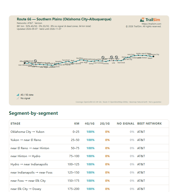
Real rows from the report you'll receive — every stage analysed, every dead zone pinned with GPS coordinates.
| Stage | km | 4G/5G | 2G/3G | No signal | Best network |
|---|---|---|---|---|---|
| Oklahoma City → Yukon | 0–25 | 100% | 0% | 0% | AT&T |
| Yukon → near El Reno | 25–50 | 100% | 0% | 0% | AT&T |
| near El Reno → near Hinton | 50–75 | 100% | 0% | 0% | AT&T |
| near Hinton → Hydro | 75–100 | 100% | 0% | 0% | AT&T |
| Hydro → near Indianapolis | 100–125 | 100% | 0% | 0% | AT&T |
| near Indianapolis → near Foss | 125–150 | 100% | 0% | 0% | AT&T |
| near Foss → near Elk City | 150–175 | 100% | 0% | 0% | AT&T |
| near Elk City → Doxey | 175–200 | 100% | 0% | 0% | AT&T |
| Doxey → near Erick | 200–225 | 100% | 0% | 0% | AT&T |
| near Erick → Fuller | 225–250 | 100% | 0% | 0% | AT&T |
| Fuller → Lela | 250–275 | 52% | 0% | 48% | AT&T |
| Lela → near McLean | 275–300 | 0% | 0% | 100% | — |
| near McLean → Jericho | 300–325 | 86% | 0% | 14% | Verizon |
| Jericho → near Groom | 325–350 | 72% | 0% | 28% | Verizon |
| near Groom → near Conway | 350–375 | 100% | 0% | 0% | AT&T |
| near Conway → Pullman | 375–400 | 96% | 0% | 4% | AT&T |
| Pullman → Soncy | 400–425 | 100% | 0% | 0% | AT&T |
| Soncy → Wildorado | 425–450 | 100% | 0% | 0% | AT&T |
| Wildorado → near Vega | 450–475 | 100% | 0% | 0% | AT&T |
| near Vega → Gruhlkey | 475–500 | 100% | 0% | 0% | AT&T |
| Gruhlkey → near Glenrio | 500–525 | 100% | 0% | 0% | AT&T |
| near Glenrio → Bard | 525–550 | 100% | 0% | 0% | AT&T |
| Bard → near Lesbia | 550–575 | 100% | 0% | 0% | AT&T |
| near Lesbia → Tucumcari | 575–600 | 100% | 0% | 0% | AT&T |
| Tucumcari → near Mesa del Puerta | 600–625 | 100% | 0% | 0% | AT&T |
| near Mesa del Puerta → Newkirk | 625–650 | 100% | 0% | 0% | AT&T |
| Newkirk → near Cuevro | 650–675 | 100% | 0% | 0% | AT&T |
| near Cuevro → near Santa Rosa | 675–700 | 100% | 0% | 0% | AT&T |
| near Santa Rosa → near Vegas Junction | 700–725 | 100% | 0% | 0% | AT&T |
| near Vegas Junction → near Potrillo Hill | 725–750 | 100% | 0% | 0% | AT&T |
| near Potrillo Hill → near Mesa Las Tapias | 750–775 | 98% | 0% | 2% | AT&T |
| near Mesa Las Tapias → Wagon Wheel | 775–800 | 78% | 0% | 22% | AT&T |
| Wagon Wheel → Jarett Place | 800–825 | 50% | 0% | 50% | Verizon |
| Jarett Place → Cedar Crest | 825–850 | 100% | 0% | 0% | AT&T |
| Cedar Crest → near Albuquerque | 850–875 | 100% | 0% | 0% | AT&T |
| near Albuquerque → Albuquerque | 875–881 | 100% | 0% | 0% | AT&T |
All 36 stages in the PDF report
| # | Near | Section | Length | Signal drops at | Returns at |
|---|---|---|---|---|---|
| 1 | Norrick | 252–260 km | 8 km | 35.22694, -100.10261 | 35.22701, -100.18518 |
…and 3 more dead zones in the PDF report
What you carry with you
The map above shows where the signal holds and where it goes. The report is the version you take with you: on the trail there is no signal, so it is a PDF you keep on your phone or print, plus a GPX track that puts every dead zone on your map app as you walk.
- Every stage of the route with its coverage, kilometre by kilometre
- The strongest network for each stage
- Every dead zone with its coordinates and GPS waypoints
- Printable PDF and a GPX track for your GPS or phone map
Included with every plan, emailed within minutes of purchase.
How this is estimated. Modelled from crowd-sourced cell-tower data (not field measurements) — real signal varies with terrain, weather and network load. Full methodology in the report. Coverage data: OpenCellID (CC-BY-SA 4.0), snapshot 2026-09-07. Route and place names: © OpenStreetMap contributors (ODbL). © 2026 TrailSim.
Frequently asked questions
Is there phone signal (cell service) on the Southern Plains section of Route 66?
On the networks TrailSim sells for the Southern Plains section of Route 66, 92% of the route's 881 km has fast 4G/5G data; 4 modelled dead zones totalling 64 km have no signal on its networks — the best-coverage plan on this page cuts this to 3 dead zones totalling 14 km. Cell service depends on which networks your eSIM roams on: the plans on TrailSim's Southern Plains section of Route 66 page are compared against exactly this route, and every dead zone is named and pinned with GPS coordinates in the coverage report included with each eSIM.
How much data do I need for the Southern Plains section of Route 66?
Route 66 — Southern Plains (Oklahoma City–Albuquerque) typically takes about 4 days — around 2 GB at 500 MB a day, and the featured plan is picked on exactly that arithmetic. Worldwide, everyday smartphone use averages about 22 GB a month — roughly 730 MB a day — most of it video streaming (Ericsson Mobility Report, Nov 2025). On the trail the picture is lighter: with maps downloaded and video saved for wifi, messaging, photos, weather and bookings run 200–400 MB a day, so we size every recommendation at 500 MB a day for comfortable headroom. Size up if you stream, video-call or share your connection. If you would rather pay only for the days you are out, TrailSim's pay-by-the-day plans for the Southern Plains section of Route 66 give a full-speed daily allowance that slows down instead of cutting off, with the number of days set on the payment page.
What is a pay-by-the-day eSIM plan?
A daily allowance of 300 MB to 1.5 GB at full speed, then slower for the rest of that day — never cut off. It is priced per day: you set the number of days (1 to 90) on the payment page, pre-filled with the typical Southern Plains section of Route 66 trip length, and the days start on first use. It suits short trips and people who would rather never run out than carry a large fixed plan; the fixed plans on the same page are cheaper per gigabyte for a long trip.
When do the plan days start counting?
On first use — installing the TrailSim eSIM and connecting starts the clock, not the purchase date. You can safely buy weeks before your trip.
Does my phone support eSIM?
Most phones released since 2019 support eSIM, including iPhone XS and later, Google Pixel 3 and later, and most recent Samsung Galaxy models. Your phone must also be carrier-unlocked.
Why not a regular travel eSIM from Airalo or Holafly?
Any eSIM connects to the same physical networks. What TrailSim adds is the route check: it compares real cell-tower data along the Southern Plains section of Route 66 itself, picks the network combination that holds best there, and includes the coverage report with every dead zone mapped — so you know before you go where the phone will and won't work. A longer comparison is at trailsim.com/compare/airalo and /compare/holafly.
What if parts of the route have no signal at all?
On most wild routes some stretches have no signal from any network — no eSIM can change that. TrailSim's Southern Plains section of Route 66 coverage report marks every dead zone with GPS coordinates and length, so you can download offline maps for those sections and tell people at home when you'll be unreachable. Knowing where it drops is the point.
What if I change my mind after buying?
Uninstalled eSIMs qualify for a full self-service refund within 14 days of purchase — no questions asked. Once the eSIM is installed on a device it can no longer be returned. See the refund policy.